
@t0mer/n8n-nodes-latlng
v2026.9.0
Published
n8n community node for LatLng — geocoding, reverse geocoding, places search and static maps
Downloads
105

Maintainers
 t0merkle!n
Readme
@t0mer/n8n-nodes-latlng


An n8n community node for LatLng. It covers forward and reverse geocoding, place search, nearby places, autosuggest and place categories. It also renders static map images and fetches vector tiles and TileJSON, all based on OpenStreetMap data.
Unofficial. This package is not affiliated with, endorsed by or supported by LatLng.
- Demo
- Installation
- Credentials
- Operations
- Coordinates
- Options
- Quota and errors
- Attribution and usage terms
- Development
Demo
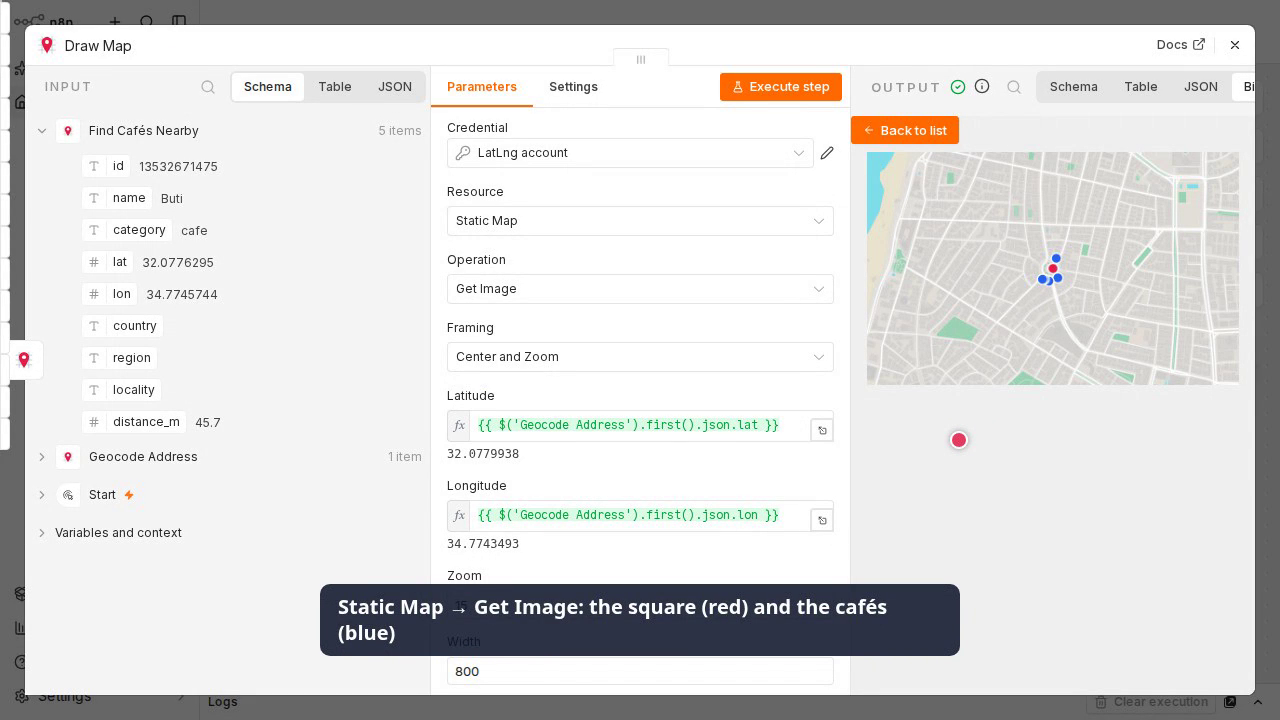
▶ Watch the demo video (MP4, 43 s)
The workflow is in demo/workflow.json:
- Geocoding → Forward looks up "Dizengoff Square, Tel Aviv".
- Place → Nearby lists 5 cafés within 500 m of it.
- Static Map → Get Image draws the square (red) and the cafés (blue).
Import the workflow and pick your LatLng credential in each LatLng node.
Installation
From the n8n UI (self-hosted n8n):
- Go to Settings → Community Nodes → Install.
- Enter
@t0mer/n8n-nodes-latlngand confirm.
Manually (e.g. Docker or queue mode):
cd ~/.n8n/nodes
npm install @t0mer/n8n-nodes-latlng
# restart n8n
See the n8n docs on installing community nodes.
Credentials
Create a LatLng API credential. You get keys from the LatLng dashboard at dash.latlng.work.
| Field | Key type | Needed for |
|---|---|---|
| API Key (Server Key), required | latlng_… | Geocoding, Place (including Autosuggest), Static Map. Sent as the X-Api-Key header. |
| Maps Key, optional | pk_latlng_… | Tile and Dataset. Sent as the key query parameter to the tiles host. |
- Put the server key in the API Key field. A Maps key (
pk_latlng_…) there makes the server-only endpoints answer403. - Tile and Dataset operations fail with a clear error if the Maps key is empty. Dataset tiles accept only a Maps key that belongs to the dataset owner.
- Test on the credential calls
GET /v1/places/categoriesonce, which counts against your quota.
Operations
Every operation's description says what it returns and in which units. The node is also marked as usable as an AI agent tool.
Geocoding
| Operation | Description | |---|---| | Forward | Address or place name → coordinates and address details. Returns up to Max Results matches (default 10), best first. | | Reverse | Latitude/longitude → the address at that point (street, city, postcode, country…). |
Example output (Forward, Simplify on, one item per match). Without Language, names come back in the local language:
{
  "name": "כיכר דיזנגוף",
  "lat": 32.0779938,
  "lon": 34.7743493,
  "osm_type": "R",
  "osm_id": 13645250,
  "osm_value": "square",
  "type": "locality",
  "city": "תל אביב–יפו",
  "country": "ישראל",
  "countrycode": "IL",
  "extent": [34.7738809, 32.0782606, 34.7745159, 32.077723]
}
Reverse returns the same fields for the address at the point.
Place
| Operation | Description |
|---|---|
| Autosuggest | Completes a partial name (at least 2 characters) as you type. Optional filters: near point, radius, country and bounding box. Default 5 results, max 20. |
| Get Categories | Lists every place category (about 40, e.g. cafe, restaurant, pharmacy). |
| Nearby | Places within a radius (meters, default 1000, max 5000) of a point, nearest first. Optional category filter. |
| Search | Places matching a name or keyword. Optional filters: near point, category and country. |
Example output (Nearby, one item per place, distance_m in meters):
{ "id": "13516609157", "name": "Plaza Café", "category": "cafe", "lat": 32.0775717, "lon": 34.7739451, "distance_m": 36.9 }Example output (Autosuggest, one item per suggestion):
{ "name": "דיזנגוף", "type": "address", "category": "street", "lat": 32.0765505, "lon": 34.7746435, "distance_m": 162, "country": "IL" }Get Categories outputs one item per category, e.g. { "category": "cafe", "osm_tag": "amenity:cafe" }.
Use the category value in the Category filter.
Static Map
| Operation | Description |
|---|---|
| Get Image | Renders a PNG or JPEG map (up to 2048×2048 pixels) as binary data in the field you choose (data by default). The file is named latlng-map.png or latlng-map.jpg. |
- Framing: Center and Zoom (latitude, longitude, zoom 0–20), or Bounding Box (min/max latitude and longitude; the zoom is fitted automatically).
- Style: light, dark (default), grayscale, black, white or contrast.
- Markers: latitude, longitude, color and a short label for each pin.
- Paths: a line through two or more points, with weight (pixels), color and opacity (0–1).
- GeoJSON Overlay: any GeoJSON object to draw on top of the map.
Current API behavior (checked September 2026): the live API draws markers in the chosen color, but it does not draw marker labels, paths or GeoJSON overlays. The request still succeeds; those parts are just missing from the image. The node sends them as LatLng documents them, so they should start working if the API adds support.
The JSON part of the output holds the request parameters (never the key) plus fileName, mimeType
and fileSize. If the request gets very long, for example with hundreds of markers, the API may reject
it. The error then suggests fewer markers or a simpler GeoJSON.
Tile and Dataset (Maps key required)
| Resource | Operation | Description |
|---|---|---|
| Tile | Get Metadata | TileJSON for the LatLng base map: bounds, zoom range, layers and attribution. |
| Tile | Get Vector Tile | One Mapbox Vector Tile (z/x/y, zoom 0–15) as binary application/x-protobuf, named {z}-{x}-{y}.pbf. |
| Dataset | Get Metadata | TileJSON for one of your uploaded datasets. |
| Dataset | Get Vector Tile | One vector tile of a dataset (zoom 0–14). |
- TileJSON echoes your key inside the
tilesURLs, so the node replaces it withkey=REDACTEDin the output. - Tile coordinates are checked before the call:
z,xandymust be whole numbers, with0 ≤ x, y < 2^z.
Coordinates
You always enter Latitude and Longitude as two separate number fields in decimal degrees. The node checks the ranges (latitude −90 to 90, longitude −180 to 180) before calling the API.
You never need to know the order a particular endpoint expects, because the node handles it:
- Query parameters use
lat/lon. - GeoJSON uses
[lon, lat]. With Simplify on, results come back as flatlat/lonfields. - Static maps use
lng,lat.
Options
| Option | Applies to | Description |
|---|---|---|
| Simplify | Geocoding, Place | On (default): one item per result, with flat fields. Off: the raw API response as one item. |
| Include Rate Limit Info | all | Adds rateLimit: { limit, remaining } from the X-RateLimit-* response headers. |
| Language | Geocoding → Forward | Preferred language for names, e.g. en, de, he. |
| Return Empty Item | Geocoding, Place (with Simplify) | If nothing is found, output { "found": false, "query": … } instead of no item. |
| Timeout | all | Request timeout in milliseconds (default 10000). |
Each output item is paired with its input item. With Continue On Fail, a failed item becomes
{ "error": "…", "statusCode": 401 } and the rest of the batch keeps running.
Quota and errors
- LatLng uses one shared quota for all calls: the free plan allows 3,000 calls per day. Every call counts, including tiles, static maps and the credential test.
429and5xxresponses are retried at most twice (after 1 s and 3 s). Other errors are not retried, because every retry costs quota.
| Status | Error shown |
|---|---|
| 400 | Bad request: <message from the API> |
| 401 | Invalid API key |
| 403 | Key not allowed for this endpoint (server vs maps key, or domain restriction) |
| 429 | LatLng quota exceeded; resets daily on the free plan |
API keys never appear in node output or error messages.
Attribution and usage terms
Map data © OpenStreetMap contributors, available under the ODbL. If you publish a static map image, show this attribution visibly near it.
Your use of the API is subject to LatLng's terms and plan limits. See latlng.work.
Development
npm install
npm run lint     # n8n-node lint (strict)
npm run build
npm test         # unit tests, no network
npm run dev      # n8n with this node loaded, at http://localhost:5678
npm run smoke calls each operation once against the real API, using keys from a local .env file
(LATLNG_API_KEY, and optionally LATLNG_MAPS_KEY). It writes sanitized responses to
test/fixtures/live/. It makes about 10 calls, so don't run it in a loop. Set LATLNG_DATASET_ID to also check a dataset.
Releases are published by pushing a YYYY.M.PATCH tag. See .github/workflows/publish.yml.