
bharat-choropleth-js
v0.2.0
Published
Accessible, dependency-light SVG choropleths for India drill-down dashboards — framework-free.

Maintainers
 shashankbudem
Readme
bharat-choropleth-js
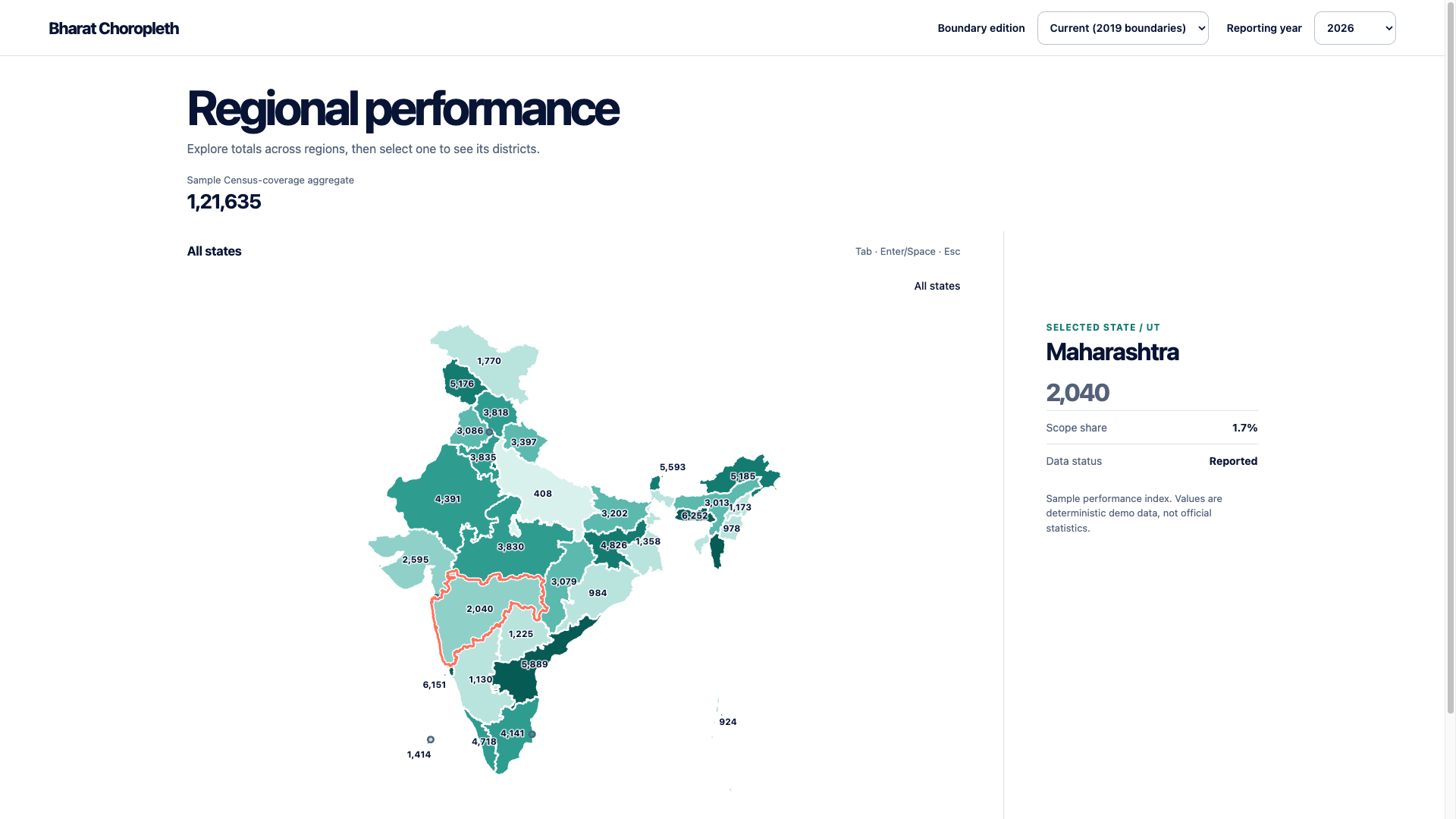
An accessible SVG India state-to-district-to-sub-district choropleth with no framework dependency. Drop one <script> tag into any HTML page, or import it as an ES module from a bundler. Same behavior, CSS classes, and stylesheet as the React bharat-choropleth package.
One script tag
<div id="map"></div>

<script src="https://cdn.jsdelivr.net/npm/[email protected]"></script>
<script>
  var map = new BharatChoropleth("#map");

  map.fontColor = "maroon";
  map.colorScale = ["#ffffff", "#800000"];

  map.goa = 6;
  map.gujarat = 7;
  map.tamil_nadu = 18;
  map.states["Jammu & Kashmir"] = 2;
</script>
That's the whole setup. No stylesheet link, no build step, no await, no boundary files to find:
- The script tag injects its own CSS. (Bundler users import
bharat-choropleth-js/style.cssinstead, so their pipeline can extract and hash it — see From a bundler.) - Boundary data is fetched, not bundled. The package ships no geometry; the prepared current-vintage state bundle is downloaded from
dataBaseUrlon construction. SetdataBaseUrlto self-host — see Boundary data. - Values set before the data arrives are applied when it arrives. Every line above runs while the download is still in flight; nothing is dropped and nothing needs awaiting.
map.readyis a promise if you want one. - Clicking a state drills into its districts, and a district into its sub-districts (tehsils / taluks / mandals / blocks), fetched from the same base URL. Pass
districts: falseorsubDistricts: falseto turn either off.
See the complete example in the repository. To run it locally, serve the repo root over HTTP (npx serve), then open /packages/js/example/bharat-choropleth.html.
Setting values
Every one of these reaches the same state, so you can use whichever your data already has:
map.goa = 6;                        // dot-notation slug
map.tamil_nadu = 18;                // underscores
map.states["Tamil Nadu"] = 18;      // display name
map.states["tamilnadu"] = 18;       // no separators
map.states["in-cs-33-tamil-nadu"]   // LGD id
map.orissa = 8;                     // former name → Odisha
Names are matched case-insensitively, with & treated as and. Orissa, Pondicherry, Uttaranchal, NCT of Delhi, J&K and similar former or colloquial names resolve to their current state. A name that matches nothing logs a console warning naming the property you typed — it never throws, and never silently does nothing. (The warning waits until the boundary data has loaded, since that is the first moment an unknown name can be told apart from one that just hasn't been matched yet.)
Other value APIs:
map.setValues({ Goa: 6, Gujarat: 7 })— many values, one re-render.map.getValues()— everything currently set, keyed by display name.values: { Goa: 6 }as a constructor option — same thing, before first paint.- District values work through the same accessor once you drill in:
map.states["North Goa"] = 3.
Options
var map = new BharatChoropleth("#map", { showRegionValues: true, districts: false });
// or, equivalently:
var map = new BharatChoropleth({ container: "#map", showRegionValues: true });
| Option | Default | Purpose |
| --- | --- | --- |
| container | #bharat-choropleth, then #map | Element or CSS selector. Also the first constructor argument. |
| geometry | fetched from dataBaseUrl | Inline GeoJSON/TopoJSON, a URL string, or a promise of either. |
| dataBaseUrl | jsDelivr copy of data/generated | Base URL for the prepared bundles. Point at your own copy to self-host. |
| districts | true with default data, else false | Click-to-drill-down into districts. |
| subDistricts | true with default data, else false | Click-to-drill-down from a district into its sub-districts. Districts the bundle has none for stay leaves. |
| fontColor / borderColor | — | Sets the --india-map-text / --india-map-stroke CSS variables. |
| borderWidth | 2.5 | Region border thickness in px. Sets --india-map-border-width. |
| selectionWidth | 3 | Selection ring thickness in px; its halo is drawn at twice this. Sets --india-map-selection-width. |
| colorScale | built-in teal ramp | Ordered low-to-high colors, or a (value, context) => color function. |
| values | {} | Initial values, keyed by any accepted spelling. |
| onReady / onError | — | Called after the data renders, or if it fails to load. |
| getId / getLabel | properties.id / properties.name | Only needed for custom geometry with different property keys. |
Options can also be set as properties after construction, in either case style — map.fontColor = "maroon" and map.font_color = "maroon" are the same assignment, and neither is mistaken for a state name.
Every thickness is a CSS variable, so you can theme without touching the renderer. Strokes are non-scaling, meaning these are true on-screen pixels no matter how far the map is scaled down:
.india-choropleth {
  --india-map-border-width: 2.5;         /* region borders */
  --india-map-border-width-active: 2;    /* hovered/focused region */
  --india-map-selection-width: 3;        /* selection ring; halo is 2x this */
}
Every other IndiaChoroplethOptions field (referenceOverlay, loadDistricts, onRegionClick, formatValue, renderTooltip, showLegend, ...) is accepted and forwarded.
Methods: setValues, getValues, select(id), drillDown(name | null), drillDownSubDistrict(id | null), getSelected(), getInspected(), destroy(). The full engine is at map.engine (null until the data loads — await map.ready first).
Hover and focus detail
Pointing at (or tabbing to) a region shows a tooltip with the region name, its formatted value, a share bar, and 26.3% of total · 1st of 36. Regions with no value say No data and show neither share nor rank — the same wording the region's aria-label uses.
- Rank counts only regions that have a value, highest first, and ties share the better rank (
1sttwice, then3rd). - Placement is anchored to the region's centroid, not the cursor, because hover and keyboard focus run through the same path and a focused region has no cursor to follow. The box shifts horizontally and flips below the centroid as needed so it never leaves the map.
- Announcement happens on focus, via
aria-describedby. The tooltip is not anaria-liveregion; it would otherwise re-read itself on every hover, and the region'saria-labelalready carries name and value.
Replace the whole thing with renderTooltip, which receives { label, value, total, share, rank, rankedCount, level, feature, id, meta } and returns a string or a DOM node:
var map = new BharatChoropleth("#map", {
  renderTooltip: function (c) {
    return c.value === null ? c.label + ": no data" : c.label + ": " + c.value + " (" + c.rank + " of " + c.rankedCount + ")";
  },
});
Boundary data
The package deliberately bundles no geographic boundaries; it downloads them. By default that means the prepared bundles in this repo's data/generated, served over jsDelivr, which must be attributed as:
State/UT, district and sub-district boundaries derived from datta07/INDIAN-SHAPEFILES (MIT).
For production, offline or air-gapped use, copy data/generated/current-2019-states/, data/generated/current-2019-districts/ and data/generated/current-2019-subdistricts/ next to your app and point at them — no third-party CDN request at runtime:
var map = new BharatChoropleth("#map", { dataBaseUrl: "/maps" });Or supply geometry directly and skip the fetch entirely, in which case the map renders synchronously:
var map = new BharatChoropleth("#map", { geometry: myTopoJson }); // or a URL stringSee the repository's data attribution for the licence and attribution of every bundle. Each asset keeps its own source's terms — don't blend the notices.
From a bundler
npm add bharat-choropleth-jsimport { BharatChoropleth } from "bharat-choropleth-js";
import "bharat-choropleth-js/style.css"; // the ESM build does not inject CSS
const map = new BharatChoropleth("#map");
map.states["Goa"] = 6;The ESM entry also exports the full IndiaChoropleth engine, the STATES registry, resolveState, ATTRIBUTION and DEFAULT_DATA_BASE_URL, plus every type.
IndiaChoropleth (full-featured engine)
BharatChoropleth is a facade for the common case. IndiaChoropleth is the engine underneath, for controlled selection, custom tooltips, reference overlays and data that isn't one-number-per-state:
const map = new IndiaChoropleth(container, options);container: anHTMLElement, or a CSS selector string resolved viadocument.querySelector.options: the same shape as the ReactIndiaChoroplethProps— seesrc/types.ts. Two slots differ because there's no JSX:renderTooltip?: (context) => string | Node— return a string (set astextContent) or a DOM node to mount directly. Omit for the built-in tooltip.renderInsights?: (context, container: HTMLElement) => void— imperatively populate the given container; called on every hover/selection change. Omit to skip the insights panel entirely.
It requires an explicit states layer with getId/getLabel/getValue accessors, and never fetches anything on your behalf. Under a script tag it is available as window.IndiaChoropleth; see the full-engine example.
Instance methods
update(partialOptions)— merge new options (new data, controlledselectedId/drillDownId, swapped callbacks) and re-render.select(id | null)— select a region at the current level without changing drill-down.drillDown(id | null)— drill into a state, or passnullto return to the state view.drillDownSubDistrict(id | null)— drill into a district's sub-districts, or passnullto return to the district view. Only meaningful while a state is drilled into, so its district layer has to have loaded first.getSelected()/getInspected()— read the currentMapRegion | null.destroy()— remove all DOM content and cancel any in-flight loads. Call this before discarding the instance.
Controlled vs. uncontrolled state works the same way as the React version: pass selectedId/drillDownId/subDistrictDrillDownId (and keep passing them via update()) for controlled usage, or defaultSelectedId/defaultDrillDownId/defaultSubDistrictDrillDownId to let the instance manage its own. A district id means nothing outside the state it came from, so changing drillDownId clears the level below it.
loadSubDistricts may return null for a district with no sub-district level; that district is left as a leaf rather than opening an empty view, and stops offering the level once it has answered.
Design notes
- Hover/focus updates never rebuild the DOM — only class names, ARIA attributes, and the tooltip/insights content change. A full rebuild only happens when the underlying region set changes (drill-down navigation, new district data arriving, or an
update()with new data). This matters in practice: rebuilding on every hover would drop keyboard focus mid-interaction. - Load-attempt tracking is keyed by drill-down id, not by "do we have data yet" — a failed
loadDistrictscall intentionally does not retry on every re-render (see the comment onattemptedDistrictLoadForIdinsrc/IndiaChoropleth.ts). src/states.tscarries state identities (id, name, slug) but no coordinates. It's what letsmap.goa = 6be recognized and validated before any boundary file has downloaded — the geometry itself still never ships in the package.- The script-tag build has its own entry (
src/iife.ts) because it does two things the ESM build must not: inject the stylesheet, and assign the constructors towindowby hand. Bundlers'globalNamewould have exposed the module namespace, making the callnew BharatChoropleth.BharatChoropleth(...).
Build
pnpm build      # ESM (dist/index.js) + script-tag IIFE (dist/bharat-choropleth.min.js) + style.css
pnpm test
pnpm typecheck