
deoverlap
v4.2.1
Published
De-overlap vector strokes to prevent overdrawing.

Maintainers
 pileoni
Readme
deoverlap
De-overlap vector strokes to prevent overdrawing.
Where strokes run on top of each other, deoverlap keeps one and cuts the others back, so no area gets drawn twice: doubled roads on a map, duplicated edges in generated art, outlines drawn twice by a pen plotter. Native Node.js bindings for a Rust engine, prebuilt for Linux (x64, arm64), macOS (x64, arm64) and Windows (x64).
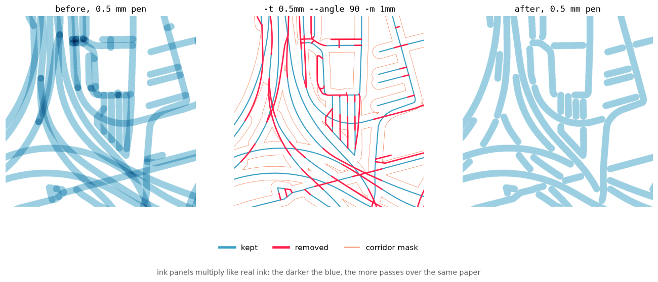
A street map drawn with a 0.5 mm pen: before (left), what was cut away (middle), after (right). Blue is kept, red is removed, orange is the corridor mask — the same colours in every figure below.
The same engine ships as a Python library and a vpype command: github.com/piLeoni/deoverlap.
Quick start
npm install deoverlapconst { deoverlap } = require("deoverlap");
const line = (x0, y0, x1, y1) => ({ coords: [x0, y0, x1, y1], offsets: [0, 4], kinds: [0] });
const result = deoverlap(
[line(0, 0, 2, 0), line(1, 0.05, 3, 0.05)], // parallel, 0.05 apart
0.1 // tolerance
);
console.log(result.kept.length); // 2: the second line is cropped
console.log(result.kept[1].geometry.coords); // starts after x ≈ 2.09
console.log(result.whollyRemoved); // []tolerance is a distance in the same units as the coordinates: strokes closer
than this to a kept stroke are cut. For a plotter, use the pen width.
Geometries are plain objects of flat number arrays (see Geometries); a GeoJSON converter is a few lines.
How it works
Geometries are processed one at a time, in priority order. Each kept stroke
gets a corridor of radius tolerance around it, and every later stroke loses
the parts that fall inside a corridor. The options below decide which stroke
goes first (prefer), which nearby strokes count as overlapping (angle),
and what to do with the leftovers of a cut stroke (drop, minLength).
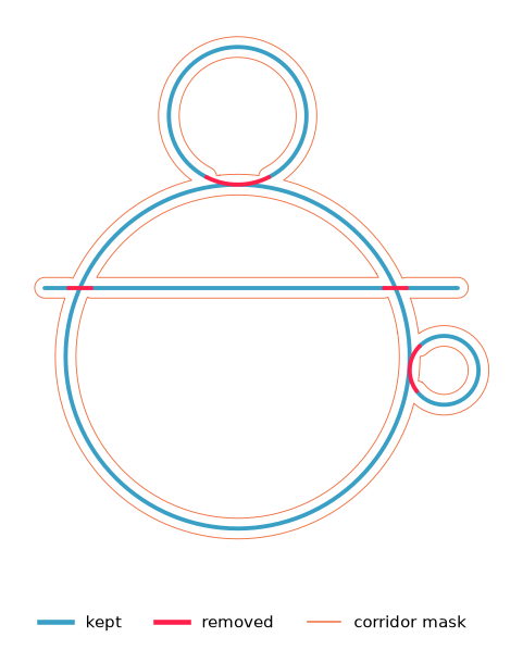
prefer — which stroke wins
The processing order decides which of two overlapping strokes is kept whole:
| prefer | Behaviour |
|---|---|
| "longest" (default) | The stroke that covers more ground wins |
| "first" | Input order |
| "shortest" | Short marks / detail win |

Every result entry carries the input index, whatever the processing order.
angle — which strokes count as overlapping
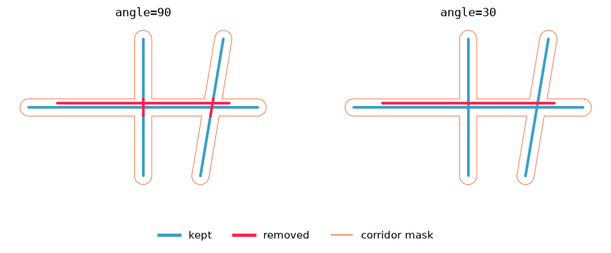
Two strokes overlap only where their directions differ by at most angle
degrees (default 30). Parallel runs and shallow merges are cropped; crossings
steeper than that are left alone. angle: 90 counts every nearby stroke, so
crossings get cut too.
deoverlap(geometries, 0.1, { angle: 90 }); // cut crossings tooDirections are compared locally, edge by edge, so a curving ramp is cropped only where it actually runs alongside another road, whatever direction its two ends point in.
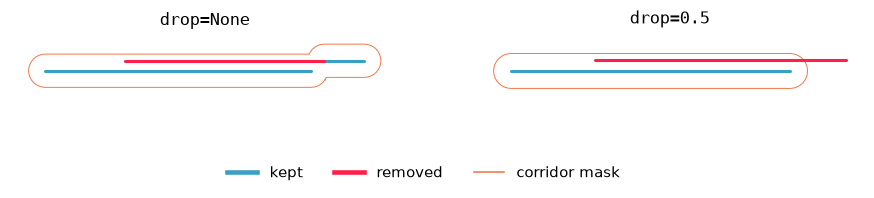
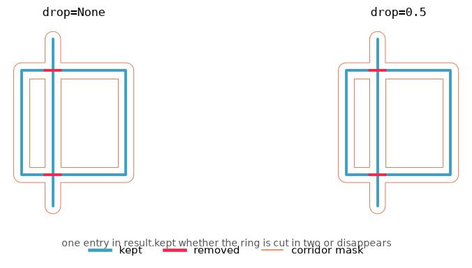
drop — crop or discard
By default the overlap is cut away and the rest of the stroke is kept. With
drop: 0.5, a stroke that would lose more than half its length is discarded
whole instead of leaving stubs; its index goes into whollyRemoved.
minLength drops pieces shorter than that after cutting (points are never
removed by it).
Split pieces stay one object
A ring crossed by another stroke is cut into two arcs. They come back as one multipart geometry under the ring's input index, not as two anonymous pieces:
const cutter = { coords: [1, -1, 1, 3], offsets: [0, 4], kinds: [0] };
const ring = { coords: [0, 0, 2, 0, 2, 2, 0, 2, 0, 0], offsets: [0, 10], kinds: [0] };

const { kept } = deoverlap([cutter, ring], 0.15, { prefer: "first", angle: 90 });
kept[1].index;            // 1
kept[1].geometry.offsets; // [0, 8, 16]: one geometry, two parts
One colour per object. On the left, what deoverlap returns: both halves of the ring are one entry. On the right, the same pieces if every part were a separate object:
selfOverlap
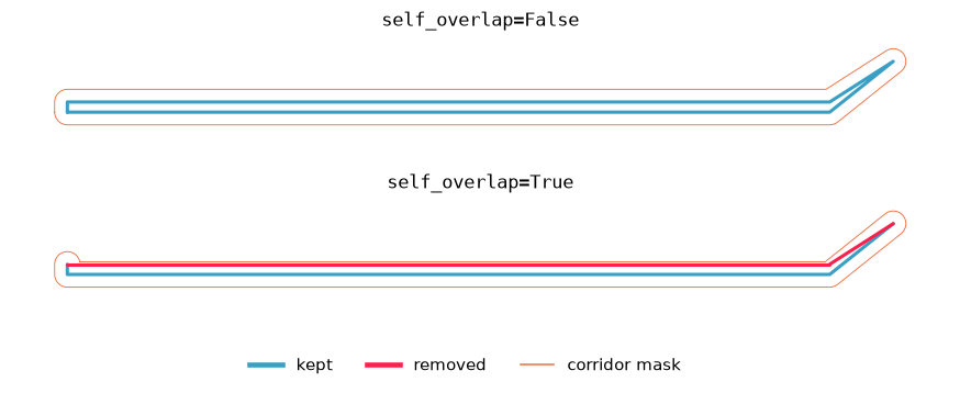
A thin road outline is often one polyline (left kerb → end cap → right
kerb). Normally deoverlap never compares a geometry to itself, so the two sides
stay as a heavy double stroke. With selfOverlap: true every edge is its own
corridor, so opposite sides can suppress each other. Neighbouring edges never
cut each other, so joints are not nibbled, unless the path folds back on itself
like a hairpin.
Multi-stage with a carried mask
To process batches separately (for example, main roads first, then side streets), pass the previous mask:
const r1 = deoverlap(mainRoads, 0.1);
const r2 = deoverlap(sideStreets, 0.1, { mask: r1.mask });
Stage 2 is clipped against everything stage 1 kept.
Options
deoverlap(geometries, tolerance, {
  prefer: "longest",     // "longest" | "first" | "shortest"
  angle: 30,             // degrees, 0–90; 90 cuts crossings too
  selfOverlap: false,
  minLength: 0,
  drop: undefined,       // fraction 0–1; undefined always crops
  keepDuplicates: false, // fill removed / removedParts
  mask: undefined,       // result.mask of a previous run
});
All options are optional; the values above are the defaults.
Result
| Field | Meaning |
|---|---|
| kept | { index, geometry } per input that kept something, in processing order |
| whollyRemoved | Indices of inputs with nothing kept |
| removed | Cut pieces as separate geometries (with keepDuplicates) |
| removedParts | { index, geometry } per input, what it lost; no geometry if nothing (with keepDuplicates) |
| mask | { capsules, polygons } corridors, for a next stage |
Geometries
Each geometry is a plain object of flat arrays:
| Field | Type | Meaning |
|---|---|---|
| coords | number[] | Every vertex: [x0, y0, x1, y1, …] |
| offsets | number[] | Start of each part in coords, plus a final entry coords.length |
| kinds | number[] | Per part: 0 = line, 1 = point |
A two-point line is offsets: [0, 4]; a geometry with two parts of four
vertices each is offsets: [0, 8, 16]. Full spec:
WIRE_FORMAT.md.
From and to GeoJSON
function fromGeoJSON(g) {
  const lines = {
    LineString: [g.coordinates],
    MultiLineString: g.coordinates,
    Polygon: g.coordinates,
    MultiPolygon: (g.coordinates || []).flat(),
  }[g.type];
  const points = { Point: [g.coordinates], MultiPoint: g.coordinates }[g.type];
  const coords = [], offsets = [0], kinds = [];
  for (const part of lines || points || []) {
    for (const [x, y] of lines ? part : [part]) coords.push(x, y);
    offsets.push(coords.length);
    kinds.push(lines ? 0 : 1);
  }
  return { coords, offsets, kinds };
}

function toGeoJSON({ coords, offsets, kinds }) {
  const parts = kinds.map((kind, i) => {
    const xy = [];
    for (let j = offsets[i]; j < offsets[i + 1]; j += 2) xy.push([coords[j], coords[j + 1]]);
    return kind === 1 ? { type: "Point", coordinates: xy[0] }
                      : { type: "LineString", coordinates: xy };
  });
  if (parts.length === 1) return parts[0];
  const type = parts[0].type;
  if (parts.some((p) => p.type !== type)) return { type: "GeometryCollection", geometries: parts };
  return { type: `Multi${type}`, coordinates: parts.map((p) => p.coordinates) };
}

const result = deoverlap(features.map((f) => fromGeoJSON(f.geometry)), 0.0001);
const cleaned = result.kept.map(({ index, geometry }) => ({
  ...features[index],
  geometry: toGeoJSON(geometry),
}));
Polygons are treated as their outlines, so they come back as lines.
Performance
The engine builds no polygons: the corridor of a straight edge is a capsule, and the part of another edge inside it is computed exactly. On the MacArthur Maze map (1473 paths) a run takes about 15 ms.
Building from source
Needs a Rust toolchain.
git clone https://github.com/piLeoni/deoverlap
cd deoverlap/bindings/node
npm install
npm run build
npm test
Map data © OpenStreetMap contributors, available under the ODbL.