
gauss-spiral
v1.0.1
Published
A library for converting between coordinates and indices using the Gauss spiral algorithm
Maintainers
 hmmhmmhm
Readme
gauss-spiral
🔗 Showcase and Introduction Page
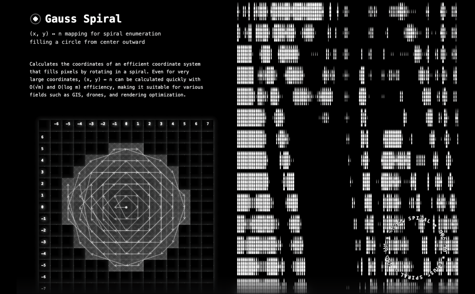
Fill a circle with dots from the center out — efficiently. Compute (x, y) ↔ n for very large cases fast (binary search + O(√m) counting, O(log m) search) with a simple, plug-and-play API — no math background needed.
Utilities to map between an integer spiral's visit order n and lattice coordinates (x, y) on Z^2.
This is NOT Gauss' circle problem nor a number-theory result. The name is only inspirational: we enumerate integer lattice points by expanding rings and ordering points on each ring by angle.
Analogy
Imagine painting dots starting at the center pixel (0, 0) and expanding outward so that the circle fills up without gaps. This library tells you:
- Given a dot's coordinate
(x, y), exactly which turnnit was placed. - Given a step
n, exactly which coordinate(x, y)to paint next.
This is handy for pixel plotting, particle systems, procedural art, or any visualization that needs a deterministic “from center outwards” spiral fill.
Benefits
- Deterministic mapping: Stable, reproducible order for every lattice point.
- Bidirectional: Convert both
(x, y) → nandn → (x, y). - Geometry-first: Simple arithmetic and
atan2ordering; no heavy number theory. - Incremental-friendly: Great for progressive rendering or streaming updates.
- Ring sampling: Easy to iterate points by radius ring for effects and batching.
- Zero dependencies: Plain TypeScript/JavaScript, small bundle.
Practical examples
Visual effects / rendering
- Progressive radial reveal, spiral particle emission, halo expansion.
- Iterate
n = 1..Nand plotgetCoordinates(n); stop whenx^2 + y^2exceeds a radius.
const maxRadius = 64; // pixels
for (let n = 1; ; n++) {
  const { x, y } = getCoordinates(n);
  if (x * x + y * y > maxRadius * maxRadius) break;
  plotPixel(centerX + x, centerY + y);
}
GIS / map tiling
- Prioritize fetching tiles around the center tile
(cx, cy)in spiral order to maximize perceived responsiveness. - Use
getCoordinates(n)as offsets from(cx, cy).
// 1) Circular tile prefetch around a focal tile (e.g., user location) async function fetchTilesSpiral(cx: number, cy: number, count: number) { const tasks: Promise<void>[] = []; for (let n = 1; n <= count; n++) { const { x, y } = getCoordinates(n); // (dx, dy) tasks.push(fetchTile(cx + x, cy + y)); } await Promise.allSettled(tasks); } // 2) Drone/robot next-search waypoints (expand search radius while staying coverage-optimal) function* droneWaypoints(cx: number, cy: number) { for (let n = 1; ; n++) { const { x, y } = getCoordinates(n); yield { latIndex: cy + y, lonIndex: cx + x }; } } // 3) Military/operations coordinate prioritization (rank tasks by circular proximity) // Known target deltas (dx, dy) can be ranked by getNFromCoordinates(dx, dy). targets.sort((a, b) => getNFromCoordinates(a.dx, a.dy) - getNFromCoordinates(b.dx, b.dy));- Prioritize fetching tiles around the center tile
Games / chunk visibility & loading
- Load chunks around the player in a circle-first fashion to avoid diamond- or square-shaped artifacts.
- Either compute loading order with
getCoordinates(n)or assign priority to known chunks viagetNFromCoordinates(dx, dy).
const maxChunks = 256;
for (let n = 1; n <= maxChunks; n++) {
  const { x, y } = getCoordinates(n);
  queueLoadChunk(player.cx + x, player.cy + y);
}

// Or rank existing chunk deltas by priority index:
chunks.sort((a, b) => getNFromCoordinates(a.dx, a.dy) - getNFromCoordinates(b.dx, b.dy));
Installation
npm install gauss-spiralUsage
Gauss Spiral Coordinates
import { getNFromCoordinates, getCoordinates } from 'gauss-spiral';

// n from (x, y): how many-th visit is this point in the spiral?
const n = getNFromCoordinates(2, 3);
console.log(n); // e.g. 47 (depends on the spiral's ordering)

// (x, y) from n: which coordinate is visited at step n?
const coords = getCoordinates(10);
console.log(coords); // { x: number, y: number }
Spherical Coordinate Grid System
The library also provides utilities for converting geographic coordinates (latitude/longitude) into a grid-based diff system, useful for spatial indexing and proximity calculations.
import {
  calculateCoordinateDiff,
  reconstructCoordinateDiff,
  DEG_PER_METER,
} from 'gauss-spiral';

// Define a center point (e.g., Seoul, South Korea)
const center = { lat: 37.5665, lng: 126.978 };

// Define a target location
const target = { lat: 37.5695, lng: 126.981 };

// Convert to grid diff with 3-meter precision
const diff = calculateCoordinateDiff({
  center,
  target,
  precisionMeters: 3,
});
console.log(diff); // { lat: 111, lng: 237 } (approximate grid indices)

// Reconstruct the original coordinates from the diff
const reconstructed = reconstructCoordinateDiff({
  center,
  diff,
  precisionMeters: 3,
});
console.log(reconstructed); // Close to original target coordinates

// Use with Gauss spiral for radial proximity search
const spiralN = getNFromCoordinates(diff.lat, diff.lng);
console.log(spiralN); // Priority index for this location
Use cases for spherical coordinate utilities:
- Geospatial indexing: Convert lat/lng to integer grid indices for efficient spatial queries
- Proximity search: Combine with Gauss spiral to prioritize locations by distance from center
- Map tile systems: Create custom grid systems with configurable precision
- Location-based services: Implement radius-based searches and nearest-neighbor queries
- Geohashing alternative: Simple grid-based spatial indexing without external dependencies
What this is
- Problem: When plotting integer points outward from the origin in an ever-growing spiral, determine
nfor a given(x, y)(index of visit), and(x, y)for a givenn(coordinate visited at step n).
- Approach: We group points by their squared radius
m = x^2 + y^2(concentric “rings”). Within each ring, points are ordered by the polar angleatan2(y, x)in clockwise order. The global indexnis the cumulative count of all points with smallermplus the position within the current ring.
Algorithm overview
- Rings: For each integer
m ≥ 0, the ring contains all integer solutions ofx^2 + y^2 = m. - Order within a ring: Sort solutions by
atan2(y, x)descending (clockwise). Ties are stable and deterministic. - Global index:
- Let
S(m)be the number of integer points withx^2 + y^2 ≤ m. - Then for
(x, y)withx^2 + y^2 = m,n = S(m-1) + k, wherekis the 1-based position in the ring.
- Let
- Inverse (n → (x, y)):
- Binary-search the smallest
mwithS(m) ≥ n. - Set
k = n - S(m-1)and return thek-th point of the ring ordered as above.
- Binary-search the smallest
API
Gauss Spiral Functions
getNFromCoordinates(x: number, y: number): number
Returns the 1-based visit index n of (x, y) in the spiral enumeration.
Parameters:
x- The x-coordinatey- The y-coordinate
Returns: The index n (≥ 1)
getCoordinates(n: number): { x: number; y: number }
Returns the lattice coordinate visited at step n.
Parameters:
n- The N value (must be > 0)
Returns: { x, y }
Throws: Error if n <= 0
Spherical Coordinate Functions
calculateCoordinateDiff(options): { lat: number; lng: number }
Converts a target coordinate to a grid diff based on a reference center coordinate. Useful for creating a grid-based spatial indexing system.
Parameters:
options.center- The reference coordinate{ lat: number, lng: number }options.target- The target coordinate to convert{ lat: number, lng: number }options.precisionMeters- (Optional) The precision in meters for the conversion. Default:3options.degreePerMeter- (Optional) Conversion factor from meters to degrees. Default:111000
Returns: { lat: number, lng: number } - The calculated grid diff for latitude and longitude
Example:
const diff = calculateCoordinateDiff({
  center: { lat: 37.5665, lng: 126.978 },
  target: { lat: 37.5695, lng: 126.981 },
  precisionMeters: 3,
});
reconstructCoordinateDiff(options): { lat: number; lng: number }
Converts a grid diff back into a coordinate based on a reference center coordinate. This reverses the operation done by calculateCoordinateDiff.
Parameters:
options.center- The reference coordinate{ lat: number, lng: number }options.diff- The grid diff representing the position{ lat: number, lng: number }options.precisionMeters- (Optional) The precision in meters used in the conversion. Default:3options.degreePerMeter- (Optional) Conversion factor from meters to degrees. Default:111000
Returns: { lat: number, lng: number } - The calculated target coordinate
Example:
const reconstructed = reconstructCoordinateDiff({
  center: { lat: 37.5665, lng: 126.978 },
  diff: { lat: 111, lng: 237 },
  precisionMeters: 3,
});
DEG_PER_METER
Constant representing the approximate conversion factor from degrees to meters. Approximately 111,000 meters corresponds to 1 degree of latitude.
Value: 111000
Performance notes
- Counting
S(m)is implemented inO(√m)using symmetry to aggregate lattice points perx. n → (x, y)uses a binary search onmaround an initial guess and then sorts only the ring points for thatm.
Caveats
- The ordering within each ring is purely geometric (by angle), not arithmetic. It does not encode primes, quadratic residues, or Gauss’ circle estimates.
- The origin
(0, 0)is defined asn = 1.
License
MIT