
geojson-shadow-generator
v1.0.6
Published
This module aims to generate shadow geometries as GeoJSON by using properties from GeoJSON files
Maintainers
 alikilic
Readme
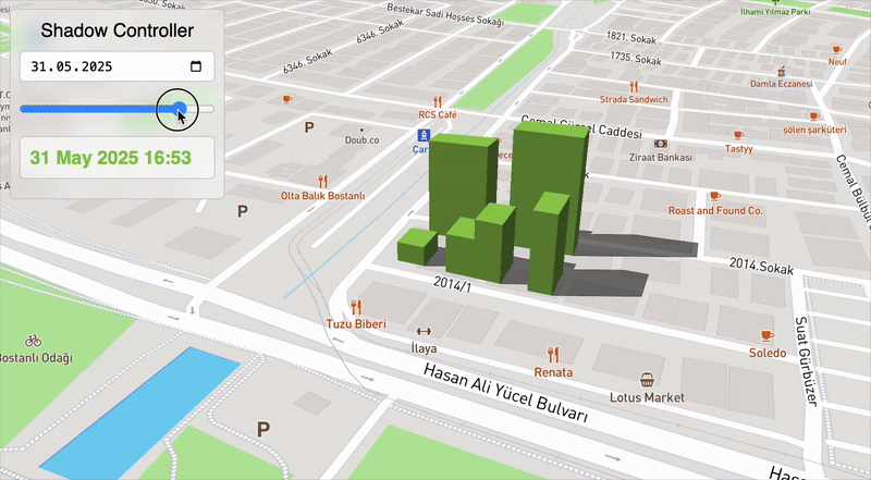
GeoJSON Shadow Generator
A powerful tool to simulate shadow geometries from 2D building footprints (as GeoJSON) using sun position (via direct angles or date-time). Supports elevation-based shadow generation and handles Polygon and MultiPolygon types.
Installation
npm install geojson-shadow-generatoror with yarn:
yarn add geojson-shadow-generatoror with vanillajs
https://cdn.jsdelivr.net/npm/geojson-shadow-generator/bundle.js✨ Features
Calculates shadow geometries based on:
- Direct sun azimuth/elevation angles.
- Automatic sun position using date-time and GeoJSON center.
Validates input GeoJSON (
FeatureorFeatureCollection).Supports
PolygonandMultiPolygongeometry types.Uses
@turfandsuncalclibraries under the hood.Returns output as a valid GeoJSON
FeatureCollectionorFeature.
Usage
Import
const GeoJSONShadowGenerator = require('geojson-shadow-generator');Example
const geojson = require('./yourGeoJSON.json');

const generator = new GeoJSONShadowGenerator(geojson, 'elevation');

// Using direct sun angles
const shadows1 = generator.getShadowGeometries({
  type: 'direct',
  sunAzimuth: 135,        // degrees from north, clockwise
  sunElevation: 30        // degrees above horizon
});

// Using date-time and automatic sun position
const shadows2 = generator.getShadowGeometries({
  type: 'datetime',
  date: '2025-06-01T10:00:00Z'
});
Constructor
new GeoJSONShadowGenerator(geojson: FeatureCollection | Feature, elevationPropertyName?: string)| Parameter | Type | Required | Description |
| ----------------------- | --------- | -------- | ----------------------------------------------------------------------------------------------- |
| geojson | GeoJSON | ✅ | Input Feature or FeatureCollection with Polygon or MultiPolygon geometries. |
| elevationPropertyName | string | ❌ | Property name in feature properties that holds the elevation value. Default is 'elevation'. |
⚙️ getShadowGeometries(options)
Generates shadow geometries.
Options
| Key | Type | Required | Description |
| -------------- | -------------------------- | --------------------------------- | ------------------------------------------------------------------------ |
| type | 'direct' | 'datetime' | ❌ | Type of shadow calculation. Default: 'direct'. |
| sunAzimuth | number | Required if type === 'direct' | Azimuth angle (degrees from north, clockwise). |
| sunElevation | number | Required if type === 'direct' | Sun elevation angle (degrees above horizon). |
| date | string (ISO format) | Required if type === 'datetime' | ISO date-time string used to calculate sun position from GeoJSON center. |
GeoJSON Requirements
- Input must be a valid GeoJSON Feature or FeatureCollection.
- Geometry type must be Polygon or MultiPolygon.
- Each feature must have a numeric
elevationproperty (or custom property if set via constructor).
Example of a valid feature:
{
  "type": "Feature",
  "geometry": {
    "type": "Polygon",
    "coordinates": [
      [
        [27.09, 38.45],
        [27.10, 38.45],
        [27.10, 38.46],
        [27.09, 38.46],
        [27.09, 38.45]
      ]
    ]
  },
  "properties": {
    "elevation": 50
  }
}
Behind the Scenes
- Uses
suncalcto compute sun azimuth and elevation from date and latitude/longitude. - Projects coordinates to EPSG:3857 to perform shadow translation in meters.
- Offsets geometry using the solar vector and elevation.
- Combines the original and translated geometries to form shadows.
- Uses Turf's
convex,difference, andunionfunctions.
Testing
Example test case:
const test = new GeoJSONShadowGenerator(geojson, 'elevation');

const result1 = test.getShadowGeometries({
  type: 'datetime',
  date: '2025-05-31T14:30:00'
});

const result2 = test.getShadowGeometries({
  type: 'direct',
  sunAzimuth: 50,
  sunElevation: 45
});
Output
The returned result is a GeoJSON FeatureCollection that represents the shadow geometries of the input features.
Dependencies
This package uses the following libraries:
License
MIT © 2025 - Ali Kilic | https://akilic.com
Tip
You can visualize the shadow outputs using:
- geojson.io
- Kepler.gl
- openlayers.org
- gislayer.com
- Or web map libraries like Leaflet, Mapbox GL, or OpenLayers.