
leaflet-panel-layers
v1.3.1
Published
Leaflet Control Layers extended for group of layers and icons legend

Readme
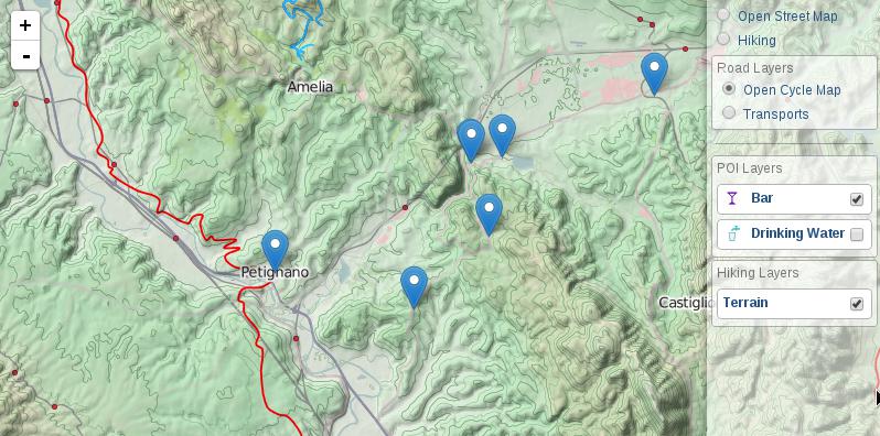
Leaflet Panel Layers
![]()
Leaflet Control Layers extended with support groups and icons
Copyright Stefano Cudini
Tested in Leaflet v1.6.x
Demo:
opengeo.tech/maps/leaflet-panel-layers
Source code:
Use Cases:
Options
| Option | Default | Description | | --------------- | -------- | ----------------------------------------- | | compact | false | panel height minor of map height | | collapsed | false | panel collapsed at startup | | autoZIndex | true | set zindex layer by order definition | | collapsibleGroups| false | groups of layers is collapsible by button | | groupCheckboxes | false | adds a checkbox to the group title to de-/select all layers in the group | | selectorGroup | false | select all layer of a group | | buildItem | null | function that return row item html node(or html string) | | title | '' | title of panel | | className | '' | additional class name for panel | | position | 'topright' | position of control |
Events
| Event | Data | Description | | ---------------------- | ---------------------- | ----------------------------------------- | | 'panel:selected' | {layerDef} | fired after moved and show markerLocation | | 'panel:unselected' | {} | fired after control was expanded |
Methods
| Method | Arguments | Description | | ---------------------- | --------------------- | -------------------------------------------------------- | | addBaseLayer() | layerDef,group,collapsed | add new layer item definition to panel as baselayers | | addOverlay() | 'Text message' | add new layer item definition to panel as overlay | | removeLayer() | 'Text searched' | remove layer item from panel | | configToControlLayers()| 'Text searched' | convert config from Control.PanelLayers to Control.Layers|
Usage
Panel Item Definition formats
	{
		name: "Bar",
		icon: iconByName('bar'),
		layer: L.geoJson(Bar, {pointToLayer: featureToMarker })
	}
definition in JSON format permit to store simply the configuration type contains a Leaflet method in this case L.geoJson() args is the arguments passed to the method: L.geoJson(river)
	{
		layer: {
			type: "geoJson",
			args: [ river ]
		},
	}
definition of a group
	{
		group: "Title Group",
		collapsed: true,
		layers: [
		...other items...
		]
	}
Multiple active layers with icons
var baseLayers = [
	{
		active: true,
		name: "OpenStreetMap",
		layer: L.tileLayer('https://{s}.tile.openstreetmap.org/{z}/{x}/{y}.png')
	}
];
var overLayers = [
	{
		name: "Drinking Water",
		icon: '<i class="icon icon-water"></i>',
		layer: L.geoJson(WaterGeoJSON)
	},
	{
		active: true,
		name: "Parking",
		icon: '<i class="icon icon-parking"></i>',
		layer: L.geoJson(ParkingGeoJSON)
	}
];
map.addControl( new L.Control.PanelLayers(baseLayers, overLayers) );
Build panel layers from pure JSON Config
var panelJsonConfig = {
    "baselayers": [
        {
            "active": true,
            "name": "Open Cycle Map",
            "layer": {
                "type": "tileLayer",
                "args": [
                    "https://{s}.tile.opencyclemap.org/cycle/{z}/{x}/{y}.png"
                ]
            }
        },
        {
            "name": "Landscape",
            "layer": {
                "type": "tileLayer",
                "args": [
                    "https://{s}.tile3.opencyclemap.org/landscape/{z}/{x}/{y}.png"
                ]
            }
        },
        {
            "name": "Transports",
            "layer": {
                "type": "tileLayer",
                "args": [
                    "https://{s}.tile2.opencyclemap.org/transport/{z}/{x}/{y}.png"
                ]
            }
        }
    ],
    "overlayers": [
        {
            "name": "Terrain",
            "layer": {
            "type": "tileLayer",
            "args": [
                "https://toolserver.org/~cmarqu/hill/{z}/{x}/{y}.png", {
                "opacity": 0.5
                }
            ]
            }
        }
    ]
};
L.control.panelLayers(panelJsonConfig.baseLayers, panelJsonConfig.overLayers).addTo(map);
Grouping of layers
L.control.panelLayers(
	[
		{
			name: "Open Street Map",
			layer: osmLayer
		},
		{
			group: "Walking layers",
			layers: [
				{
					name: "Open Cycle Map",
					layer: L.tileLayer('https://{s}.tile.opencyclemap.org/cycle/{z}/{x}/{y}.png')
				},
				{
					name: "Hiking",
					layer: L.tileLayer("https://toolserver.org/tiles/hikebike/{z}/{x}/{y}.png")
				}
			]
		},
		{
			group: "Road layers",
			layers: [
				{
					name: "Transports",
					layer: L.tileLayer("https://{s}.tile2.opencyclemap.org/transport/{z}/{x}/{y}.png")
				}
			]
		}
	],
	{collapsibleGroups: true}
).addTo(map);
Collapse some layers' groups
L.control.panelLayers([
	{
		name: "Open Street Map",
		layer: osmLayer
	},
	{
		group: "Walking layers",
		layers: [
			{
				name: "Open Cycle Map",
				layer: L.tileLayer('https://{s}.tile.opencyclemap.org/cycle/{z}/{x}/{y}.png')
			},
			{
				name: "Hiking",
				layer: L.tileLayer("https://toolserver.org/tiles/hikebike/{z}/{x}/{y}.png")
			}
		]
	},
	{
		group: "Road layers",
		collapsed: true,
		layers: [
			{
				name: "Transports",
				layer: L.tileLayer("https://{s}.tile2.opencyclemap.org/transport/{z}/{x}/{y}.png")
			}
		]
	}
]).addTo(map);
Add layers dynamically at runtime
var panel = L.control.panelLayers();

$.getJSON('some/url/path.geojson', function(data){
	panel.addOverlay({
		name: "Drinking Water",
		icon: '<i class="icon icon-water"></i>',
		layer: L.geoJson(data)
	});
});
Build
This plugin support Grunt for building process. Therefore the deployment require NPM installed in your system. After you've made sure to have npm working, run this in command line:
npm install
grunt