
leaflet-tile-filter
v0.0.2
Published
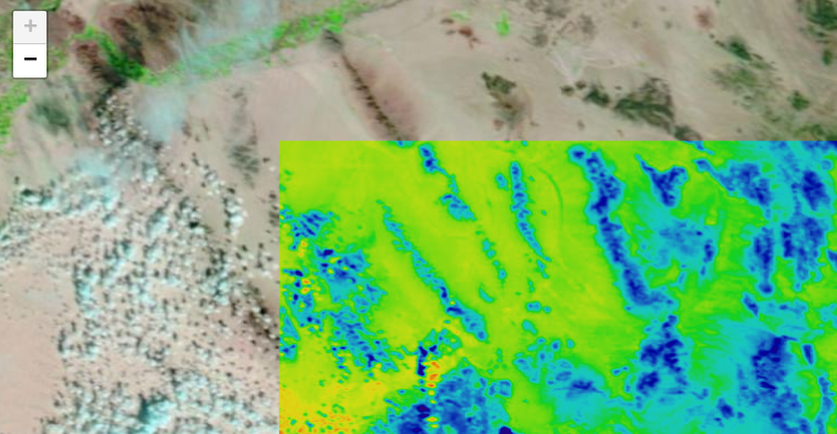
This [Leaflet](https://leafletjs.org) plugin provides multispectral channel manipulation and processing tools (such as NDVI or other remote sensing methods) for Leaflet tile layers using pure client-side JavaScript. It uses [image-sequencer](https://githu

Readme
Leaflet.TileFilter
This Leaflet plugin provides multispectral channel manipulation and processing tools (such as NDVI or other remote sensing methods) for Leaflet tile layers using pure client-side JavaScript. It uses image-sequencer and was developed by Public Lab.
It is based on the simpler plugin for ImageOverlays at https://github.com/publiclab/leaflet-multispectral
It is available as a node module as leaflet-tile-filter.
This library was made possible in part by NASA's AREN project.
Usage
See the demo for basic usage: https://publiclab.github.io/leaflet-tile-filter/
// create an tile layer
var tileLayer = L.tileLayer(
'https://gibs-{s}.earthdata.nasa.gov/wmts/epsg3857/best/' +
'{layer}/default/{time}/{tileMatrixSet}/{z}/{y}/{x}.jpg',
{
layer: 'MODIS_Terra_CorrectedReflectance_Bands721',
tileMatrixSet: 'GoogleMapsCompatible_Level9',
maxZoom: 9,
time: '2013-11-04',
tileSize: 256,
subdomains: 'abc',
noWrap: true,
continuousWorld: true,
// Prevent Leaflet from retrieving non-existent tiles on the
// borders.
bounds: [
[-85.0511287776, -179.999999975],
[85.0511287776, 179.999999975]
],
attribution:
'<a href="https://wiki.earthdata.nasa.gov/display/GIBS">' +
'NASA EOSDIS GIBS</a> ' +
'<a href="https://github.com/nasa-gibs/web-examples/blob/master/examples/leaflet/webmercator-epsg3857.js">' +
'View Source' +
'</a>'
});
// apply a colormap:
tileLayer.filter('colormap');
tileLayer.addTo(map);To revert the image to it's previous state, use:
tileLayer.revert();Multi-step commands
With a small change coming in Image Sequencer, multi-step commands and the full Image Sequencer syntax will be available:
// apply NDVI equation to the image, and then a colormap:
tileLayer.filter('ndvi,colormap');
For more complex commands, you can use JavaScript expresssions, in the following format:
tileLayer.filter('dynamic{red:R*2|green:B|blue:B/2}');In this example, we're using Image Sequencer's dynamic module to set the displayed RGB values individually, with the expressions R*2, B, and B/2, respectively.
Image Sequencer
(coming soon) Commands you can pass into the filter are extremely flexible; they are Image Sequencer string syntax (full object notation coming soon). Read about Image Sequencer and how to use it here:
https://github.com/publiclab/image-sequencer
Using the visual editor, you can develop a command string to pass into this filter:
https://sequencer.publiclab.org
Image Sequencer is implemented in pure JavaScript, and is under development; we expect optimizations as well as worker threads and WebAssembly to improve performance in upcoming versions.
About Multispectral imagery
Learn about multi-band imagery, some of it's uses at this great blog post by Charlie Lloyd of Mapbox:
https://blog.mapbox.com/putting-landsat-8s-bands-to-work-631c4029e9d1
Here's some sources of Landsat 8 data:
- https://www.mapbox.com/bites/00145/
- https://aws.amazon.com/blogs/aws/start-using-landsat-on-aws/
Here's more on NDVI and DIY techniques to collect multi-band imagery: https://publiclab.org/infragram
Multispectral TMS tile sources
- https://earthdata.nasa.gov/about/science-system-description/eosdis-components/global-imagery-browse-services-gibs
- https://wiki.earthdata.nasa.gov/display/GIBS/Map+Library+Usage
- https://github.com/nasa-gibs/gibs-web-examples/tree/master/examples/leaflet
- https://wiki.earthdata.nasa.gov/display/GIBS/GIBS+Available+Imagery+Products#expand-CorrectedReflectance16Products
- https://gibs.earthdata.nasa.gov/wmts/epsg4326/best/MODIS_Terra_CorrectedReflectance_Bands721/default/2013-08-21/250m/${z}/${y}/${x}.jpg
- https://gibs.earthdata.nasa.gov/wmts/epsg4326/best/MODIS_Aqua_CorrectedReflectance_TrueColor/default/2013-08-21/250m/${z}/${y}/${x}.jpg
Additional multi-band imagery
- https://github.com/mapbox/landsat-tiler - demo: https://viewer.remotepixel.ca/#3/40/-70.5
- https://wiki.openstreetmap.org/wiki/Landsat